
Reality Capture Services for Real Estate & Residential
Reality Capture & 3D Scanning Services for Architecture, Engineering & Construction
Real Estate Developers
//
Property Managers
//
Real Estate Agents & Brokers
//
Homeowners & Property Owners
//
Architects & Residential Designers
//
Luxury Home Builders
//
General Contractors & Remodelers
//
Interior Designers & Space Planners
//
Historic Home Preservationists
//
Real Estate Marketing Professionals
//
Surveyors & Land Planners
//
Vacation Rental & Airbnb Hosts
//
Real Estate Developers // Property Managers // Real Estate Agents & Brokers // Homeowners & Property Owners // Architects & Residential Designers // Luxury Home Builders // General Contractors & Remodelers // Interior Designers & Space Planners // Historic Home Preservationists // Real Estate Marketing Professionals // Surveyors & Land Planners // Vacation Rental & Airbnb Hosts //
Our 3D scanning and reality capture services provide real estate professionals, developers, and homeowners with high-precision as-built documentation, ensuring accurate measurements for renovations, sales, and property management. Whether you're a real estate agent looking to enhance listings with detailed floor plans and virtual tours, or a property manager needing precise as-built models for maintenance and remodeling, our technology streamlines the process. Using 3D laser scanning and photogrammetry, we deliver high-resolution point clouds, CAD-ready drawings, and interactive digital twins that help optimize space planning, property visualization, and historical documentation.
For real estate developers, architects, and homebuilders, our 3D scanning solutions provide a detailed, data-rich foundation for construction planning, renovations, and restorations. Our services ensure accurate site measurements, helping contractors and remodelers reduce errors, streamline workflows, and improve cost estimation. Luxury homebuilders and interior designers benefit from our precise 3D models and as-built plans, which allow for seamless customization and better design coordination. From historic townhomes and brownstones to modern residential properties, our technology offers a powerful way to visualize, document, and transform residential spaces with confidence.

Our Reality Capture Services for Real Estate & Residential
-

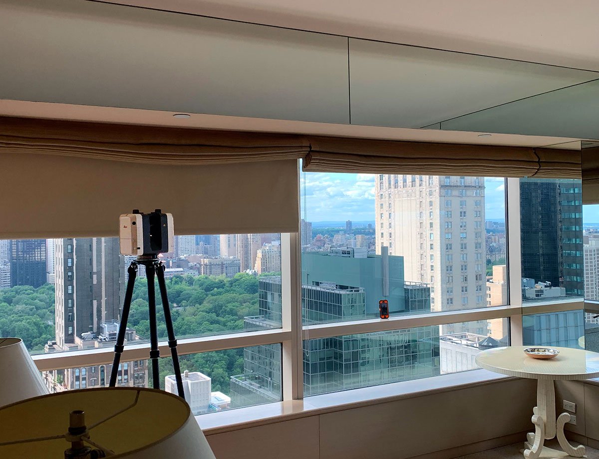
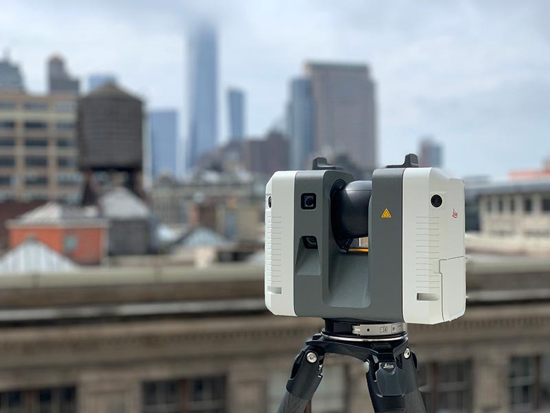
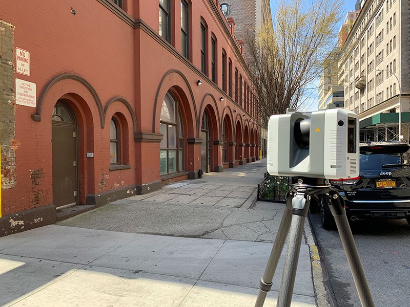
3D Laser Scanning
Our 3D laser scanning services provide high-precision reality capture for real estate professionals, offering detailed point clouds, as-built models, and accurate site measurements for renovations, space planning, and documentation.
-

As Built & Existing Conditions Surveys
We create as-built drawings, floor plans, and existing conditions surveys for property listings, renovations, and legal documentation. Deliverables include CAD files, PDFs, Point Clouds and Revit models, ensuring seamless project planning and compliance.
-

Drone Surveying & Aerial Mapping
Using high-resolution drone imagery, we provide aerial property surveys, orthophotos, topographic mapping, and facade inspections, delivering valuable insights for real estate developers, landowners, and construction teams.
-

Scan to 3D BIM Models
Our Scan to BIM services convert 3D scans into detailed, BIM-ready models, enabling architects, developers, and contractors to work with accurate digital representations of existing structures for renovations, expansions, and facility management.
-

Digital Twin Services
We create interactive digital twins of residential and commercial properties, allowing property managers, real estate developers, and facility teams to access accurate 3D models for maintenance, planning, and asset management.
-

3D Meshing & Modeling
Our 3D modeling and meshing services transform scan data into detailed architectural and property models, supporting real estate marketing, urban planning, and design visualization with accurate site representations.


Real Estate Trusts MYND.
Leading real estate developers, property managers, and architects trust MYND Workshop for precise 3D scanning, as-built documentation, and digital twin solutions. With a proven track record of delivering high-accuracy data for residential, commercial, and historic properties, we have worked with top industry leaders to support property acquisitions, renovations, and facility management. Our expertise in reality capture, drone surveys, and BIM modeling ensures that every project—whether a single-family home or a large-scale development—is documented with unmatched precision and reliability.
Select Applications & Use Cases for Real Estate & Residential
-
Real Estate Portfolio Documentation
We provide comprehensive 3D scanning and property documentation services for developers managing multiple assets, ensuring quick access to accurate site data for future renovations, leasing, and transactions.
-

Floor Plans & Site Plans
We produce accurate CAD and DWG floor plans, site layouts, and as-built drawings for property listings, real estate development, and legal documentation, ensuring compliance and clear property visualization.
-

Virtual Tours & Walkthroughs
We capture high-resolution 360° imagery and Matterport-style virtual tours, creating immersive digital walkthroughs for property marketing, investor presentations, and leasing visualization.
-
Topographic Surveys & Land Mapping
We generate terrain models, contour maps, and site grading plans using drone photogrammetry and LiDAR to support land development, zoning, and site feasibility studies.
-

Facilities Management Models
Our BIM and IFC-based facility management models provide accurate digital twins of mechanical rooms, MEP systems, and building infrastructure, ensuring efficient maintenance and long-term asset tracking.
-

Floor Flatness & Levelness Scanning
We deliver detailed elevation maps, concrete flatness analysis, and surface heat maps to assist with renovations, flooring replacements, and quality control in real estate projects.
-

Roof & Facade Inspections
Using drone-based inspections and orthophotos, we deliver detailed, high-resolution imagery for structural assessments, maintenance planning, and real estate due diligence.
-

Renderings & 3D Visuals
Our high-accuracy 3D scans provide the foundation for renderings and visualizations, helping architects, developers, and marketing teams showcase properties, neighborhoods, and design concepts with real-world accuracy.
Servicing Locations Across the U.S.A.
With 10 strategic hubs across the United States, MYND Workshop's Reality Capture & 3D Scanning services are more accessible than ever, especially to our clients on the East and West Coasts. Our central hub in Dallas further enhances our reach, ensuring we can efficiently serve clients nationwide and even internationally, without compromising on our commitment to quality and precision.


Frequently Asked Questions
-
3D laser scanning provides high-precision as-built documentation, capturing accurate floor plans, elevations, and site conditions for renovations, marketing, and property management. It eliminates manual measuring errors, speeds up project planning, and ensures reliable data for architects, developers, and real estate professionals.
-
As-built drawings provide accurate floor plans, site layouts, and existing conditions documentation, ensuring that contractors, architects, and property owners have reliable data for renovations, additions, and legal compliance. These detailed plans reduce costly mistakes and help visualize space modifications before construction begins.
-
Digital twin technology creates interactive 3D models of properties, allowing property managers, developers, and facility teams to track building conditions, plan maintenance, and optimize asset management. These models enhance long-term decision-making, real estate investment planning, and operational efficiency.
-
Drone surveying captures high-resolution aerial imagery, orthophotos, and topographic data, providing developers, landowners, and construction teams with accurate site analysis. It is essential for land mapping, roof and facade inspections, and pre-construction planning, saving time and improving safety.
-
3D scanning enhances property marketing by generating high-resolution virtual tours, 360° walkthroughs, and interactive floor plans. These assets help real estate agents, developers, and property owners attract buyers, improve engagement, and provide a realistic representation of spaces before site visits.
-
We provide as-built floor plans, CAD drawings (DWG, DXF), Revit models (BIM), 3D point clouds, and digital twins, ensuring that architects, property managers, and contractors receive the right format for design, permitting, and facility management.
-
Our 3D laser scanning and as-built surveys achieve millimeter-level accuracy, ensuring highly precise documentation of floor plans, elevations, mechanical rooms, and site conditions for architects, engineers, and developers.
-
Yes! Our 3D scanning and Scan to BIM services create highly detailed digital models of historic homes and heritage buildings, preserving architectural details for restorations, additions, and adaptive reuse projects.
-
The cost of 3D laser scanning depends on factors such as property size, level of detail required, site accessibility, and deliverables needed (e.g., point clouds, CAD drawings, BIM models). Pricing can range from a few hundred dollars for small spaces to several thousand for large-scale projects. Contact us for a customized quote based on your project’s needs.