
Reality Capture Services for Washington, DC
High-Resolution 3D Scanning & Digital Documentation for Washington, DC & the Metro Area

Our Reality Capture services for Washington, DC provide architects, cultural institutions, and developers with precise 3D documentation of historical buildings, government sites, and large-scale infrastructure projects. Using LiDAR, photogrammetry, and drone-based scanning, we create detailed digital twins, 3D models, and point clouds to aid in restoration, visualization, and planning.
We serve Washington, DC, and surrounding areas, including Arlington, Alexandria, and Bethesda. Whether scanning government buildings for digital preservation, capturing urban environments for virtual production, or creating high-accuracy as built documentation, our services ensure accuracy and efficiency.
Our 3D Scanning & Reality Capture Services for Washington, DC and the Metro Area
-

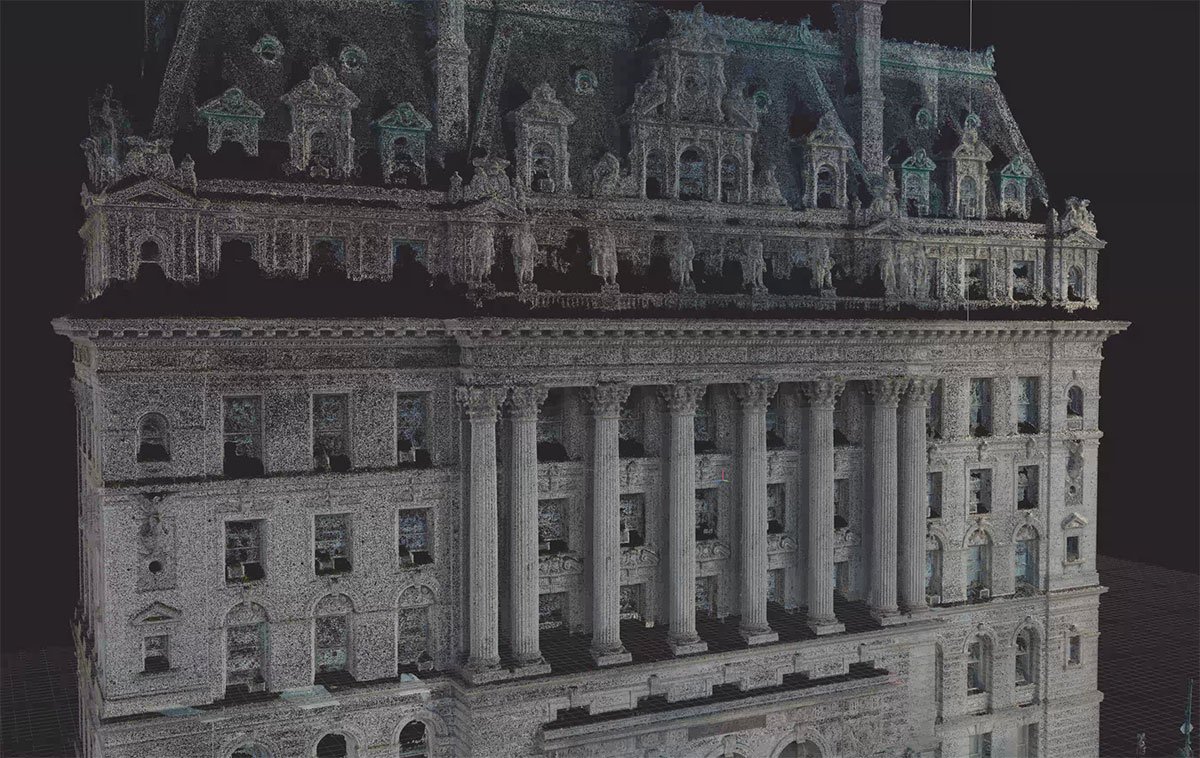
3D Laser Scanning
We capture high-precision 3D point clouds using LiDAR scanning, delivering accurate spatial data for architecture, engineering, construction, and preservation.
-

As Built Surveys
Our as built drawings provide detailed CAD and BIM-ready floor plans, elevations, and sections, ensuring accurate documentation for renovations and facility management.
-

Scan to BIM
We convert point cloud data into Revit BIM models, allowing seamless integration of existing conditions into digital workflows for design, planning, and construction.
-

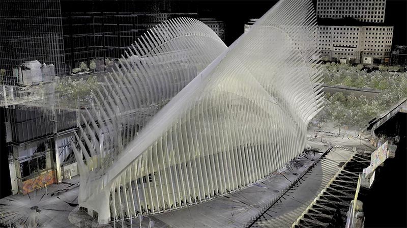
Drone Survey Services
Using aerial LiDAR and photogrammetry, we produce orthophotos, topographic maps, and facade inspections, improving site analysis, land surveys, and real estate visualization.
-

Digital Twins
We create high-fidelity digital twins—interactive, data-rich 3D models that enhance facility management, industrial monitoring, and virtual asset tracking.
-

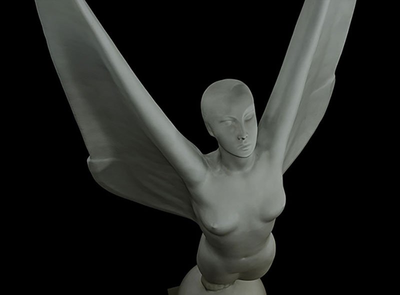
Decorative Finishes Scanning
We capture high-resolution 3D scans of fine art, murals, and architectural ornamentation, aiding conservation, restoration, and replica fabrication.
-

Environment & Locations Scanning
Our 3D environment scanning provides VFX, gaming, and virtual production teams with real-world digital backlots, HDRI imagery, and CGI-ready locations.
-

Scan Meshing & 3D Modeling
We refine raw scan data into optimized 3D meshes, offering retopology, UV mapping, and NURBs modeling for fabrication, animation, and digital assets.


Industry Leaders Trust MYND.
Washington, DC’s architects, government agencies, and museum professionals trust MYND Workshop for high-accuracy reality capture. Our work supports historic documentation, infrastructure management, and digital archiving. Contact us today to schedule your Reality Capture project in Washington, DC.
Industries We Serve in Washington, DC and the Metro Area
-
Architecture, Engineering & Construction
We provide precise 3D scanning, BIM-ready data, and accurate as-built documentation to support design, construction, and renovation projects.
-

Historic Preservation
Our advanced scanning and documentation services capture every detail of historic structures to support restoration and preservation efforts.
-

Real Estate & Residential
From property documentation to detailed renovation plans, we deliver accurate scans and 3D models for real estate professionals and homeowners.
-

Art & Fabrication
We offer precise 3D scanning and modeling services to help artists, artisans and fabricators create, replicate, and innovate.
-

Media & Entertainment
From props to film sets and environments, we provide high-quality 3D scans for visual effects, gaming, and virtual production.
-

Museums & Heritage
Our scanning and digitization services preserve artifacts, artworks, and cultural heritage with exceptional detail and accuracy.
Providing 3D Scanning & Reality Capture Across the U.S.A.
With 10 strategic hubs across the United States, MYND Workshop's 3D laser scanning services are more accessible than ever, especially to our clients on the East and West Coasts. Our central hub in Dallas further enhances our reach, ensuring we can efficiently serve clients nationwide and even internationally, without compromising on our commitment to quality and precision.


Frequently Asked Questions
-
Reality capture enables precise 3D documentation of national monuments, government buildings, and cultural landmarks, ensuring accurate records for restoration, security planning, and historical preservation.
-
Yes! We provide LiDAR and photogrammetry scanning for roadways, bridges, and large-scale construction projects, improving planning, asset management, and public works initiatives.
-
We specialize in 3D scanning of sculptures, paintings, and historic interiors, supporting museum conservation, digital archives, and interactive virtual exhibits.
-
Yes, our terrestrial laser scanning services provide high-accuracy data for urban redevelopment, CAD backgrounds, BIM models and more across the DC metro area.