
Drone Survey Services for Elizabeth, NJ
High-Precision Aerial Data & Drone LiDAR for Elizabeth & Northern New Jersey

Our drone survey services for Elizabeth provide detailed aerial mapping, point clouds, and orthophotos for a range of industries, including construction, real estate development, and asset management. Using UAV-mounted LiDAR and photogrammetry, we generate highly accurate terrain models, roof inspections, and large-scale site documentation.
We serve Elizabeth and surrounding areas, including Newark, Union, Linden, and Rahway. Whether scanning logistics hubs near the Port of Elizabeth or conducting drone-based facade assessments for industrial properties, our technology ensures precision and efficiency.
Drone Surveying & Mapping - Select Applications
-

Aerial Photogrammetry & Orthophotography
We generate high-resolution orthophotos and aerial photogrammetry models, providing georeferenced imagery for land surveys, urban planning, and site assessments.
-

LiDAR Surveys for High-Precision Mapping
Our drone-mounted LiDAR systems create detailed topographic maps and point clouds, allowing for high-density elevation modeling and vegetation penetration.
-

Construction Site Monitoring & Progress Tracking
Monitor construction progress in real-time with drone-based aerial surveys, volumetric calculations, and 3D site documentation, improving efficiency and reducing errors.
-

Topographic & Land Surveys
Using drone photogrammetry and LiDAR, we create accurate terrain models, contour maps, and elevation profiles for land development, zoning, and grading analysis.
-

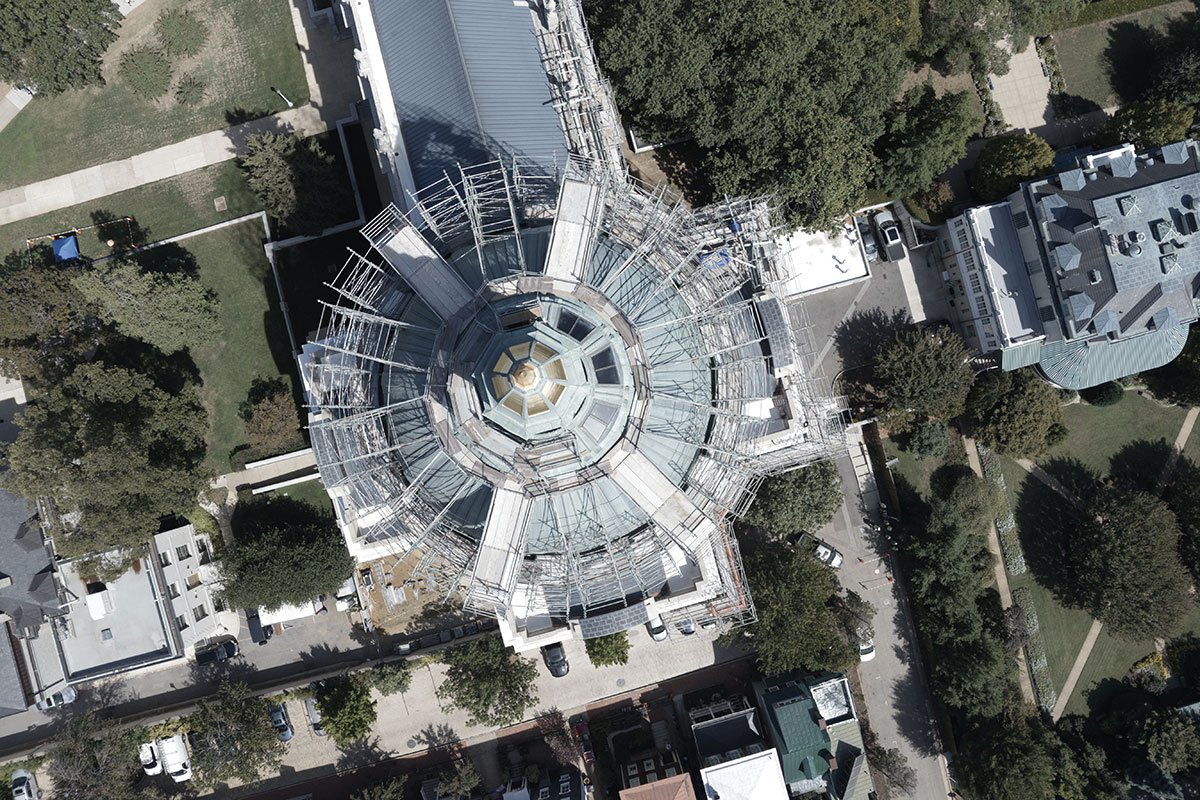
Roof & Facade Inspections
Our drones provide detailed roof and facade imaging, offering high-resolution condition assessments for commercial, industrial, and historic structures.
-
Infrastructure & Asset Inspections
We conduct drone-based inspections of bridges, towers, power lines, and industrial facilities, capturing high-resolution imagery for structural assessments and maintenance planning.


Industry Leaders Trust MYND.
Elizabeth’s developers, engineers, and real estate professionals trust MYND Workshop for high-accuracy drone surveying. Our work supports large-scale industrial planning, asset inspections, and urban development. Contact us today to schedule your drone survey in Elizabeth.
Industries We Serve in Elizabeth and Northern New Jersey
-

Architecture, Engineering & Construction
We provide precise 3D scanning, BIM-ready data, and accurate as-built documentation to support design, construction, and renovation projects.
-

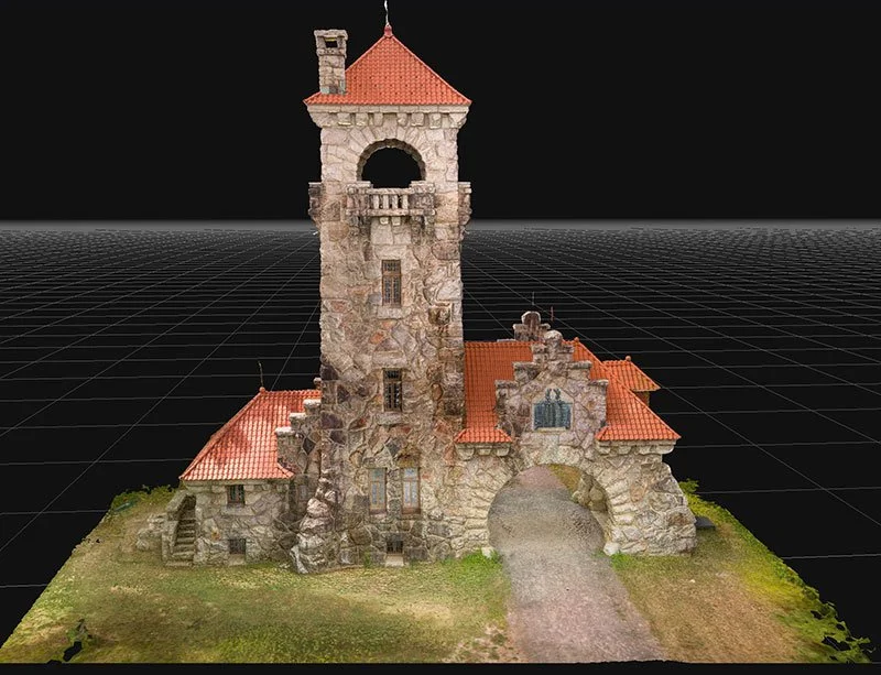
Historic Preservation
Our advanced scanning and documentation services capture every detail of historic structures to support restoration and preservation efforts.
-

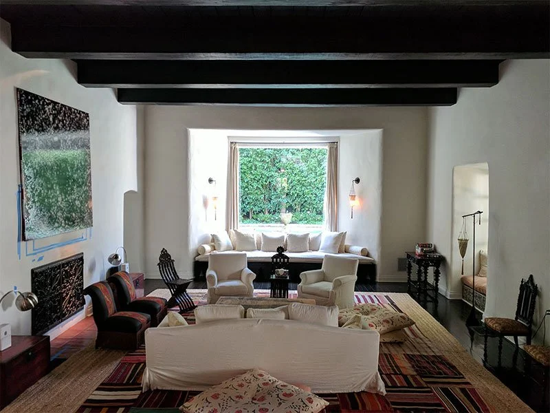
Real Estate & Residential
From property documentation to detailed renovation plans, we deliver accurate scans and 3D models for real estate professionals and homeowners.
-

Art & Fabrication
We offer precise 3D scanning and modeling services to help artists, artisans and fabricators create, replicate, and innovate.
-

Media & Entertainment
From props to film sets and environments, we provide high-quality 3D scans for visual effects, gaming, and virtual production.
-

Museums & Heritage
Our scanning and digitization services preserve artifacts, artworks, and cultural heritage with exceptional detail and accuracy.
Providing Drone Survey Services Across the U.S.A.
With 10 strategic hubs across the United States, MYND Workshop's 3D laser scanning services are more accessible than ever, especially to our clients on the East and West Coasts. Our central hub in Dallas further enhances our reach, ensuring we can efficiently serve clients nationwide and even internationally, without compromising on our commitment to quality and precision.


Frequently Asked Questions
-
Drone surveying uses UAV technology to capture high-resolution aerial imagery and LiDAR data, generating topographic maps, orthophotos, and 3D models for site analysis.
-
Drone surveys reduce time and costs, provide high-resolution data, and allow for safer access to difficult or hazardous terrain compared to traditional ground-based methods.
-
Drone LiDAR can achieve centimeter-level accuracy, making it ideal for topographic surveys, grading analysis, and terrain modeling in engineering and construction.
-
We deliver georeferenced orthophotos (GeoTIFF), point clouds (LAS, E57), elevation models (DEM, DSM), and CAD-compatible DXF files, ensuring seamless integration with your workflow.
-
Yes, our drones provide regular aerial progress updates, volumetric calculations, and as-built documentation, improving project tracking and site logistics.
-
Drone surveying is widely used in construction, civil engineering, real estate, land development, environmental monitoring, and infrastructure inspections.
-
We use advanced photogrammetry and LiDAR processing software to generate 3D terrain models, point clouds, and high-resolution maps, ensuring accurate data interpretation.
-
Pricing depends on site size, data resolution, and project complexity. Contact us for a custom quote tailored to your survey needs.